


Montferrer . El Castel . Puig de Vilafort - retour par la piste

stef789
User GUIDE
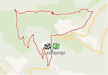

Length
7.8 km

Max alt
1121 m

Uphill gradient
331 m
Km-Effort
12.2 km

Min alt
788 m

Downhill gradient
329 m
Boucle
Yes
Creation date :
2022-08-12 13:52:32.774
Updated on :
2022-08-12 16:33:10.199
2h38
Difficulty : Easy

FREE GPS app for hiking
 SityTrail
IGN / Geographical institutes
SityTrail Plus
The world is yours!
About
Trail Walking of 7.8 km to be discovered at Occitania, Pyrénées-Orientales, Montferrer. This trail is proposed by stef789.
Photos


Positioning
Country:
France
Region :
Occitania
Department/Province :
Pyrénées-Orientales
Municipality :
Montferrer
Location:
Unknown
Start:(Dec)
Start:(UTM)
464415 ; 4698494 (31T) N.
Comments