


GTJ jour 10

werth
User
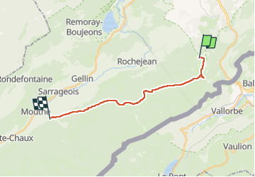

Length
15.9 km

Max alt
1450 m

Uphill gradient
286 m
Km-Effort
21 km

Min alt
934 m

Downhill gradient
658 m
Boucle
No
Creation date :
2022-08-13 05:36:21.737
Updated on :
2022-08-13 13:18:25.903
6h35
Difficulty : Medium

FREE GPS app for hiking
 SityTrail
IGN / Geographical institutes
SityTrail Plus
The world is yours!
About
Trail Walking of 15.9 km to be discovered at Bourgogne-Franche-Comté, Doubs, Longevilles-Mont-d'Or. This trail is proposed by werth.
Positioning
Country:
France
Region :
Bourgogne-Franche-Comté
Department/Province :
Doubs
Municipality :
Longevilles-Mont-d'Or
Location:
Unknown
Start:(Dec)
Start:(UTM)
297727 ; 5180480 (32T) N.
Comments