


GTJ jour 9

werth
User
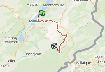

Length
14.9 km

Max alt
1416 m

Uphill gradient
749 m
Km-Effort
23 km

Min alt
848 m

Downhill gradient
286 m
Boucle
No
Creation date :
2022-08-12 06:07:02.419
Updated on :
2022-08-13 13:27:40.141
8h31
Difficulty : Difficult

FREE GPS app for hiking
 SityTrail
IGN / Geographical institutes
SityTrail Plus
The world is yours!
About
Trail Walking of 14.9 km to be discovered at Bourgogne-Franche-Comté, Doubs, Malbuisson. This trail is proposed by werth.
Positioning
Country:
France
Region :
Bourgogne-Franche-Comté
Department/Province :
Doubs
Municipality :
Malbuisson
Location:
Unknown
Start:(Dec)
Start:(UTM)
294263 ; 5186614 (32T) N.
Comments