


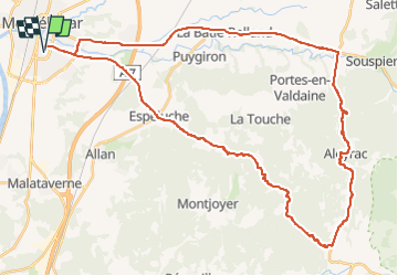
Montélimar Aleyrac 49km

thonyc
User GUIDE

Length
49 km

Max alt
485 m

Uphill gradient
658 m
Km-Effort
58 km

Min alt
88 m

Downhill gradient
658 m
Boucle
Yes
Creation date :
2022-08-13 18:43:17.956
Updated on :
2022-08-13 18:44:28.999
3h29
Difficulty : Medium

FREE GPS app for hiking
 SityTrail
IGN / Geographical institutes
SityTrail Plus
The world is yours!
About
Trail Road bike of 49 km to be discovered at Auvergne-Rhône-Alpes, Drôme, Montélimar. This trail is proposed by thonyc.
Positioning
Country:
France
Region :
Auvergne-Rhône-Alpes
Department/Province :
Drôme
Municipality :
Montélimar
Location:
Unknown
Start:(Dec)
Start:(UTM)
639195 ; 4933907 (31T) N.
Comments