


circuit des oiseaux (ancien)

papiou
User

Length
10.6 km

Max alt
25 m

Uphill gradient
59 m
Km-Effort
11.4 km

Min alt
14 m

Downhill gradient
60 m
Boucle
Yes
Creation date :
2022-08-14 07:03:54.471
Updated on :
2022-08-14 13:42:48.508
2h19
Difficulty : Medium

FREE GPS app for hiking
 SityTrail
IGN / Geographical institutes
SityTrail Plus
The world is yours!
About
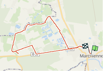
Trail Walking of 10.6 km to be discovered at Hauts-de-France, Nord, Marchiennes. This trail is proposed by papiou.
Description
ne pas faire. certaines traces du circuit n'existe plus et on arrive dans une impasse près d'une ferme avec un fermier très désagréable
Positioning
Country:
France
Region :
Hauts-de-France
Department/Province :
Nord
Municipality :
Marchiennes
Location:
Unknown
Start:(Dec)
Start:(UTM)
520010 ; 5584036 (31U) N.
Comments