


14.08.2022 - Longemer - Lispach

delm
User
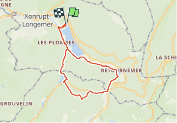

Length
14.9 km

Max alt
998 m

Uphill gradient
397 m
Km-Effort
20 km

Min alt
733 m

Downhill gradient
395 m
Boucle
Yes
Creation date :
2022-08-14 09:37:16.0
Updated on :
2022-08-14 15:21:06.052
4h08
Difficulty : Very difficult

FREE GPS app for hiking
 SityTrail
IGN / Geographical institutes
SityTrail Plus
The world is yours!
About
Trail Walking of 14.9 km to be discovered at Grand Est, Vosges, Xonrupt-Longemer. This trail is proposed by delm.
Positioning
Country:
France
Region :
Grand Est
Department/Province :
Vosges
Municipality :
Xonrupt-Longemer
Location:
Unknown
Start:(Dec)
Start:(UTM)
347121 ; 5327200 (32U) N.
Comments