


no 22 au milieu coule une riviere

jpfrobert
User
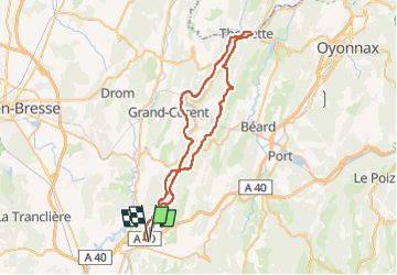

Length
57 km

Max alt
681 m

Uphill gradient
1380 m
Km-Effort
75 km

Min alt
253 m

Downhill gradient
1378 m
Boucle
Yes
Creation date :
2022-08-16 07:13:14.877
Updated on :
2022-08-16 07:24:53.843
18h40
Difficulty : Very easy

FREE GPS app for hiking
 SityTrail
IGN / Geographical institutes
SityTrail Plus
The world is yours!
About
Trail Electric bike of 57 km to be discovered at Auvergne-Rhône-Alpes, Ain, Poncin. This trail is proposed by jpfrobert.
Positioning
Country:
France
Region :
Auvergne-Rhône-Alpes
Department/Province :
Ain
Municipality :
Poncin
Location:
Unknown
Start:(Dec)
Start:(UTM)
686130 ; 5106783 (31T) N.
Comments