


St die-col de la madeleine-17km

ZAMBAUX
User
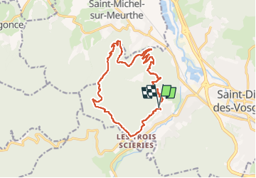

Length
16.3 km

Max alt
670 m

Uphill gradient
683 m
Km-Effort
25 km

Min alt
363 m

Downhill gradient
688 m
Boucle
Yes
Creation date :
2022-08-17 07:32:02.463
Updated on :
2022-08-17 14:31:58.776
4h32
Difficulty : Very difficult

FREE GPS app for hiking
 SityTrail
IGN / Geographical institutes
SityTrail Plus
The world is yours!
About
Trail Walking of 16.3 km to be discovered at Grand Est, Vosges, Saint-Dié-des-Vosges. This trail is proposed by ZAMBAUX.
Positioning
Country:
France
Region :
Grand Est
Department/Province :
Vosges
Municipality :
Saint-Dié-des-Vosges
Location:
Unknown
Start:(Dec)
Start:(UTM)
344826 ; 5350105 (32U) N.
Comments