


La boucle des Clarines

micheldutilleul
User
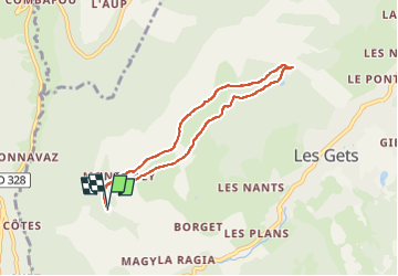

Length
6.6 km

Max alt
1610 m

Uphill gradient
185 m
Km-Effort
9.1 km

Min alt
1468 m

Downhill gradient
185 m
Boucle
Yes
Creation date :
2022-08-18 11:17:12.879
Updated on :
2022-08-18 17:31:13.335
1h48
Difficulty : Easy

FREE GPS app for hiking
 SityTrail
IGN / Geographical institutes
SityTrail Plus
The world is yours!
About
Trail Walking of 6.6 km to be discovered at Auvergne-Rhône-Alpes, Upper Savoy, Les Gets. This trail is proposed by micheldutilleul.
Description
Balades où petits et grands pourrons admirer le Mont-Blanc...
Du Mont Caly au Mont Chéry
Positioning
Country:
France
Region :
Auvergne-Rhône-Alpes
Department/Province :
Upper Savoy
Municipality :
Les Gets
Location:
Unknown
Start:(Dec)
Start:(UTM)
316938 ; 5113358 (32T) N.
Comments