


Le tour de Penne

Glurps
User
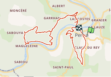

Length
15.2 km

Max alt
309 m

Uphill gradient
614 m
Km-Effort
23 km

Min alt
107 m

Downhill gradient
627 m
Boucle
Yes
Creation date :
2022-08-20 09:06:05.0
Updated on :
2022-08-20 14:52:09.102
5h21
Difficulty : Difficult

FREE GPS app for hiking
 SityTrail
IGN / Geographical institutes
SityTrail Plus
The world is yours!
About
Trail Walking of 15.2 km to be discovered at Occitania, Tarn, Penne. This trail is proposed by Glurps.
Positioning
Country:
France
Region :
Occitania
Department/Province :
Tarn
Municipality :
Penne
Location:
Unknown
Start:(Dec)
Start:(UTM)
398553 ; 4881070 (31T) N.
Comments