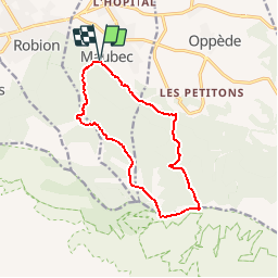
Trail Walking Maubec - Maubec-Oppède - Photo
© OpenStreetMap contributors
Length
Length
12.7 km
Max alt
Max alt
693 m
Uphill gradient
Uphill gradient
705 m
Km-Effort
Km-Effort  
22 km
Min alt
Min alt
142 m
Downhill gradient
Downhill gradient
707 m
Boucle
Boucle
Yes
Creation date :
2014-12-10 00:00:00.0
Updated on :
2014-12-10 00:00:00.0

(0 Reviews)

Walking
Walking
3h16
Difficulty : Medium

Scan this QR Code to open this trail in the SityTrail application

FREE GPS app for hiking

Logo SityTrail SityTrail

IGN / Geographical institutes

Download SityTrail from the App Store Download SityTrail from Google Play

Logo SityTrail SityTrail Plus

The world is yours!

Download SityTrail from the App Store Download SityTrail from Google Play Download SityTrail on Huawei AppGallery

About

Trail Walking of 12.7 km to be discovered at Provence-Alpes-Côte d'Azur, Vaucluse, Maubec. This trail is proposed by MarcLEBARON.

Description

Boucle.
Départ depuis le camping de Maubec par la draille des frère Nouguier puis montée par le vallon de la Sapine jusqu'au "Aires de Bédoin".
Redescendre au 1er balisage (ouest d'Oppède le vieux) par le pittoresque Vallon de Combrès (Attention passages aériens et pentues).
Retour par le GR6-GR97 avec encore quelques raidillons...

Elevation profile

Photos

Positioning

Country:
France
Region :
Provence-Alpes-Côte d'Azur
Department/Province :
Vaucluse
Municipality :
Maubec
Location:
Unknown
Start:(UTM)
671431 ; 4856372 (31T) N.


Close
My subscriptions