


Boucle dans les Chambarans vers Châtenay - 21 août 2022

morganee
User
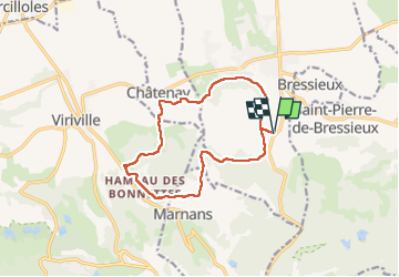

Length
13.1 km

Max alt
575 m

Uphill gradient
340 m
Km-Effort
17.7 km

Min alt
380 m

Downhill gradient
339 m
Boucle
Yes
Creation date :
2022-08-21 11:07:32.371
Updated on :
2022-08-21 14:51:48.851
3h00
Difficulty : Easy

FREE GPS app for hiking
 SityTrail
IGN / Geographical institutes
SityTrail Plus
The world is yours!
About
Trail Walking of 13.1 km to be discovered at Auvergne-Rhône-Alpes, Isère, Saint-Siméon-de-Bressieux. This trail is proposed by morganee.
Positioning
Country:
France
Region :
Auvergne-Rhône-Alpes
Department/Province :
Isère
Municipality :
Saint-Siméon-de-Bressieux
Location:
Unknown
Start:(Dec)
Start:(UTM)
677528 ; 5020124 (31T) N.
Comments