


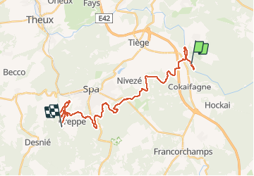
Trail du Petit Poucet

SERGIO110_1
User

Length
25 km

Max alt
452 m

Uphill gradient
666 m
Km-Effort
34 km

Min alt
264 m

Downhill gradient
651 m
Boucle
No
Creation date :
2014-12-10 00:00:00.0
Updated on :
2014-12-10 00:00:00.0
1h40
Difficulty : Difficult

FREE GPS app for hiking
 SityTrail
IGN / Geographical institutes
SityTrail Plus
The world is yours!
About
Trail Running of 25 km to be discovered at Wallonia, Liège, Jalhay. This trail is proposed by SERGIO110_1.
Positioning
Country:
Belgium
Region :
Wallonia
Department/Province :
Liège
Municipality :
Jalhay
Location:
Sart
Start:(Dec)
Start:(UTM)
709931 ; 5599276 (31U) N.
Comments