


2022 08 ARBONNE T4

michel1025
User
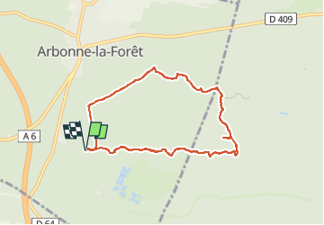

Length
7.2 km

Max alt
130 m

Uphill gradient
124 m
Km-Effort
8.9 km

Min alt
78 m

Downhill gradient
124 m
Boucle
Yes
Creation date :
2022-08-21 13:20:39.0
Updated on :
2022-08-22 09:50:40.712
2h25
Difficulty : Medium

FREE GPS app for hiking
 SityTrail
IGN / Geographical institutes
SityTrail Plus
The world is yours!
About
Trail Walking of 7.2 km to be discovered at Ile-de-France, Seine-et-Marne, Arbonne-la-Forêt. This trail is proposed by michel1025.
Positioning
Country:
France
Region :
Ile-de-France
Department/Province :
Seine-et-Marne
Municipality :
Arbonne-la-Forêt
Location:
Unknown
Start:(Dec)
Start:(UTM)
467877 ; 5360818 (31U) N.
Comments