


Ruoms 22/08/22

Linerou
User
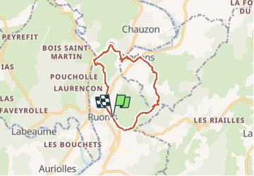

Length
11.6 km

Max alt
257 m

Uphill gradient
306 m
Km-Effort
15.7 km

Min alt
109 m

Downhill gradient
307 m
Boucle
Yes
Creation date :
2022-08-22 07:36:37.094
Updated on :
2022-08-22 12:33:28.311
3h22
Difficulty : Difficult

FREE GPS app for hiking
 SityTrail
IGN / Geographical institutes
SityTrail Plus
The world is yours!
About
Trail Walking of 11.6 km to be discovered at Auvergne-Rhône-Alpes, Ardèche, Ruoms. This trail is proposed by Linerou.
Positioning
Country:
France
Region :
Auvergne-Rhône-Alpes
Department/Province :
Ardèche
Municipality :
Ruoms
Location:
Unknown
Start:(Dec)
Start:(UTM)
607047 ; 4923126 (31T) N.
Comments