


GTJ jour 19 et le dernier.

werth
User
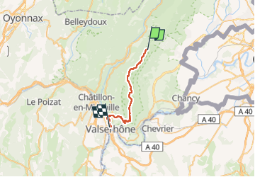

Length
23 km

Max alt
1610 m

Uphill gradient
537 m
Km-Effort
34 km

Min alt
344 m

Downhill gradient
1600 m
Boucle
No
Creation date :
2022-08-22 05:52:14.952
Updated on :
2022-08-22 16:39:48.957
10h29
Difficulty : Very difficult

FREE GPS app for hiking
 SityTrail
IGN / Geographical institutes
SityTrail Plus
The world is yours!
About
Trail Walking of 23 km to be discovered at Auvergne-Rhône-Alpes, Ain, Péron. This trail is proposed by werth.
Positioning
Country:
France
Region :
Auvergne-Rhône-Alpes
Department/Province :
Ain
Municipality :
Péron
Location:
Unknown
Start:(Dec)
Start:(UTM)
723551 ; 5121966 (31T) N.
Comments