


GITE ETAPE MESNIL SAINT PERE 6.7 km

GOELERANDO2
User
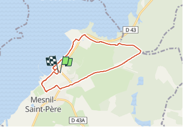

Length
6.7 km

Max alt
172 m

Uphill gradient
76 m
Km-Effort
7.7 km

Min alt
130 m

Downhill gradient
76 m
Boucle
Yes
Creation date :
2022-08-23 14:22:41.29
Updated on :
2022-08-23 14:26:48.419
1h45
Difficulty : Medium

FREE GPS app for hiking
 SityTrail
IGN / Geographical institutes
SityTrail Plus
The world is yours!
About
Trail Walking of 6.7 km to be discovered at Grand Est, Aube, Mesnil-Saint-Père. This trail is proposed by GOELERANDO2.
Positioning
Country:
France
Region :
Grand Est
Department/Province :
Aube
Municipality :
Mesnil-Saint-Père
Location:
Unknown
Start:(Dec)
Start:(UTM)
599428 ; 5345595 (31U) N.
Comments