


balade montpezat le fau

raab
User
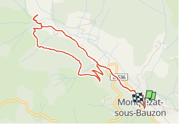

Length
5.7 km

Max alt
823 m

Uphill gradient
264 m
Km-Effort
9.3 km

Min alt
561 m

Downhill gradient
271 m
Boucle
Yes
Creation date :
2022-08-23 16:20:34.386
Updated on :
2022-08-23 19:34:31.431
3h13
Difficulty : Medium

FREE GPS app for hiking
 SityTrail
IGN / Geographical institutes
SityTrail Plus
The world is yours!
About
Trail Walking of 5.7 km to be discovered at Auvergne-Rhône-Alpes, Ardèche, Montpezat-sous-Bauzon. This trail is proposed by raab.
Positioning
Country:
France
Region :
Auvergne-Rhône-Alpes
Department/Province :
Ardèche
Municipality :
Montpezat-sous-Bauzon
Location:
Unknown
Start:(Dec)
Start:(UTM)
595673 ; 4951567 (31T) N.
Comments