


villers les moivrons

any1950
User
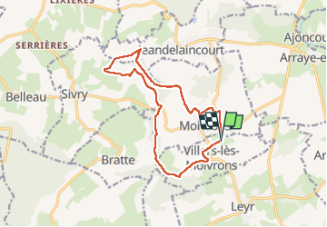

Length
12.8 km

Max alt
406 m

Uphill gradient
317 m
Km-Effort
17 km

Min alt
229 m

Downhill gradient
315 m
Boucle
Yes
Creation date :
2022-08-24 06:33:53.222
Updated on :
2022-08-24 10:18:27.372
3h44
Difficulty : Difficult

FREE GPS app for hiking
 SityTrail
IGN / Geographical institutes
SityTrail Plus
The world is yours!
About
Trail Walking of 12.8 km to be discovered at Grand Est, Meurthe-et-Moselle, Villers-lès-Moivrons. This trail is proposed by any1950.
Description
13kms 318 den
Positioning
Country:
France
Region :
Grand Est
Department/Province :
Meurthe-et-Moselle
Municipality :
Villers-lès-Moivrons
Location:
Unknown
Start:(Dec)
Start:(UTM)
298578 ; 5410954 (32U) N.
Comments