


château d'Allègre

elorthiois
User
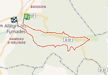

Length
8.5 km

Max alt
350 m

Uphill gradient
214 m
Km-Effort
11.5 km

Min alt
127 m

Downhill gradient
253 m
Boucle
No
Creation date :
2022-08-24 06:42:34.442
Updated on :
2022-08-24 10:29:02.642
3h45
Difficulty : Easy

FREE GPS app for hiking
 SityTrail
IGN / Geographical institutes
SityTrail Plus
The world is yours!
About
Trail Walking of 8.5 km to be discovered at Occitania, Gard, Allègre-les-Fumades. This trail is proposed by elorthiois.
Positioning
Country:
France
Region :
Occitania
Department/Province :
Gard
Municipality :
Allègre-les-Fumades
Location:
Unknown
Start:(Dec)
Start:(UTM)
599788 ; 4894923 (31T) N.
Comments