


vieille tourbière et Escarpelle par la cite Belleforriere

dehemjacques
User

Length
6.8 km

Max alt
52 m

Uphill gradient
67 m
Km-Effort
7.7 km

Min alt
14 m

Downhill gradient
66 m
Boucle
Yes
Creation date :
2022-08-24 11:21:01.23
Updated on :
2022-08-24 11:21:05.186
1h44
Difficulty : Medium

FREE GPS app for hiking
 SityTrail
IGN / Geographical institutes
SityTrail Plus
The world is yours!
About
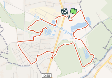
Trail Walking of 6.8 km to be discovered at Hauts-de-France, Nord, Roost-Warendin. This trail is proposed by dehemjacques.
Positioning
Country:
France
Region :
Hauts-de-France
Department/Province :
Nord
Municipality :
Roost-Warendin
Location:
Unknown
Start:(Dec)
Start:(UTM)
507877 ; 5584268 (31U) N.
Comments