


Vallée de la SAULX Savonnière

Nono55
User
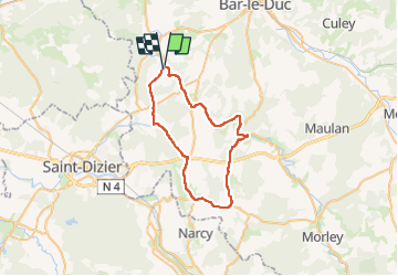

Length
40 km

Max alt
283 m

Uphill gradient
443 m
Km-Effort
46 km

Min alt
164 m

Downhill gradient
443 m
Boucle
Yes
Creation date :
2022-08-23 15:18:57.0
Updated on :
2022-08-25 16:14:59.712
1h47
Difficulty : Medium

FREE GPS app for hiking
 SityTrail
IGN / Geographical institutes
SityTrail Plus
The world is yours!
About
Trail Road bike of 40 km to be discovered at Grand Est, Meuse, L'Isle-en-Rigault. This trail is proposed by Nono55.
Description
Super sortie
Un peu chaud
Bonne route
Montée de Lavincourt bien
Positioning
Country:
France
Region :
Grand Est
Department/Province :
Meuse
Municipality :
L'Isle-en-Rigault
Location:
Unknown
Start:(Dec)
Start:(UTM)
650778 ; 5398031 (31U) N.
Comments