


2022-08-25_18h32m59_menetreux-le-pitois

jeanboulay
User
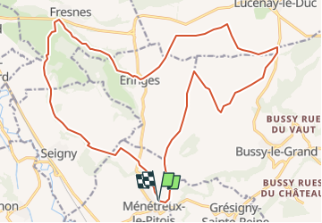

Length
24 km

Max alt
423 m

Uphill gradient
361 m
Km-Effort
29 km

Min alt
252 m

Downhill gradient
361 m
Boucle
Yes
Creation date :
2022-08-25 16:32:59.727
Updated on :
2022-08-25 16:32:58.45

FREE GPS app for hiking
 SityTrail
IGN / Geographical institutes
SityTrail Plus
The world is yours!
About
Trail of 24 km to be discovered at Bourgogne-Franche-Comté, Côte-d'Or, Ménétreux-le-Pitois. This trail is proposed by jeanboulay.
Positioning
Country:
France
Region :
Bourgogne-Franche-Comté
Department/Province :
Côte-d'Or
Municipality :
Ménétreux-le-Pitois
Location:
Unknown
Start:(Dec)
Start:(UTM)
610777 ; 5268467 (31T) N.
Comments