


20kM St Heand

bena42
User
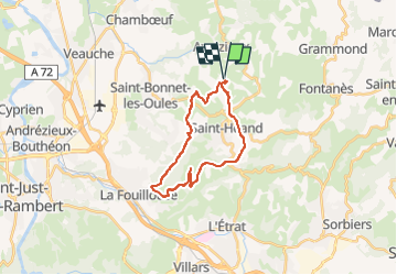

Length
21 km

Max alt
742 m

Uphill gradient
556 m
Km-Effort
29 km

Min alt
428 m

Downhill gradient
557 m
Boucle
Yes
Creation date :
2022-08-26 19:23:06.486
Updated on :
2022-08-26 19:23:44.323
2h00
Difficulty : Medium

FREE GPS app for hiking
 SityTrail
IGN / Geographical institutes
SityTrail Plus
The world is yours!
About
Trail Mountain bike of 21 km to be discovered at Auvergne-Rhône-Alpes, Loire, Saint-Héand. This trail is proposed by bena42.
Positioning
Country:
France
Region :
Auvergne-Rhône-Alpes
Department/Province :
Loire
Municipality :
Saint-Héand
Location:
Unknown
Start:(Dec)
Start:(UTM)
607273 ; 5045119 (31T) N.
Comments