


bibemus vers zola

jefflesmilles
User
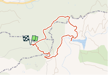

Length
4.4 km

Max alt
354 m

Uphill gradient
141 m
Km-Effort
6.2 km

Min alt
222 m

Downhill gradient
141 m
Boucle
Yes
Creation date :
2022-08-27 07:03:41.686
Updated on :
2022-08-27 08:33:32.401
1h29
Difficulty : Very easy

FREE GPS app for hiking
 SityTrail
IGN / Geographical institutes
SityTrail Plus
The world is yours!
About
Trail Walking of 4.4 km to be discovered at Provence-Alpes-Côte d'Azur, Bouches-du-Rhône, Aix-en-Provence. This trail is proposed by jefflesmilles.
Description
à pied
Positioning
Country:
France
Region :
Provence-Alpes-Côte d'Azur
Department/Province :
Bouches-du-Rhône
Municipality :
Aix-en-Provence
Location:
Unknown
Start:(Dec)
Start:(UTM)
701983 ; 4822842 (31T) N.
Comments