


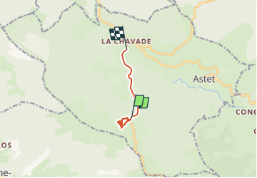
La Chavade 27/08/22

Linerou
User

Length
5.8 km

Max alt
1425 m

Uphill gradient
68 m
Km-Effort
7.2 km

Min alt
1269 m

Downhill gradient
207 m
Boucle
No
Creation date :
2022-08-27 06:45:03.117
Updated on :
2022-08-27 09:03:59.211
1h05
Difficulty : Easy

FREE GPS app for hiking
 SityTrail
IGN / Geographical institutes
SityTrail Plus
The world is yours!
About
Trail Walking of 5.8 km to be discovered at Auvergne-Rhône-Alpes, Ardèche, Astet. This trail is proposed by Linerou.
Positioning
Country:
France
Region :
Auvergne-Rhône-Alpes
Department/Province :
Ardèche
Municipality :
Astet
Location:
Unknown
Start:(Dec)
Start:(UTM)
581160 ; 4946956 (31T) N.
Comments