


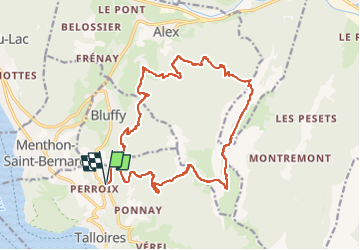
Balade dans le Lanfonnet depuis Perroix

gregou74
User

Length
20 km

Max alt
1838 m

Uphill gradient
1824 m
Km-Effort
45 km

Min alt
652 m

Downhill gradient
1822 m
Boucle
Yes
Creation date :
2022-08-27 14:31:08.893
Updated on :
2022-08-27 14:35:04.168
0m
Difficulty : Difficult

FREE GPS app for hiking
 SityTrail
IGN / Geographical institutes
SityTrail Plus
The world is yours!
About
Trail Running of 20 km to be discovered at Auvergne-Rhône-Alpes, Upper Savoy, Talloires-Montmin. This trail is proposed by gregou74.
Description
Vélo : Annecy -> Perroix
Trail : Perroix -> Col des Frêtes -> Talamarche -> Trou de la Chapelle - > Perroix
Vélo : Perroix -> Annecy
Positioning
Country:
France
Region :
Auvergne-Rhône-Alpes
Department/Province :
Upper Savoy
Municipality :
Talloires-Montmin
Location:
Talloires
Start:(Dec)
Start:(UTM)
283964 ; 5081403 (32T) N.
Comments