


titi

noelphil
User
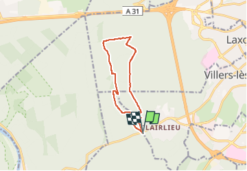

Length
10.1 km

Max alt
387 m

Uphill gradient
152 m
Km-Effort
12.1 km

Min alt
292 m

Downhill gradient
153 m
Boucle
Yes
Creation date :
2022-07-21 12:58:29.796
Updated on :
2022-08-29 11:53:09.913
1h20
Difficulty : Difficult

FREE GPS app for hiking
 SityTrail
IGN / Geographical institutes
SityTrail Plus
The world is yours!
About
Trail Walking of 10.1 km to be discovered at Grand Est, Meurthe-et-Moselle, Chaligny. This trail is proposed by noelphil.
Description
foret de haye
Positioning
Country:
France
Region :
Grand Est
Department/Province :
Meurthe-et-Moselle
Municipality :
Chaligny
Location:
Unknown
Start:(Dec)
Start:(UTM)
286670 ; 5393005 (32U) N.
Comments