


saint cirgues en montagne

raab
User
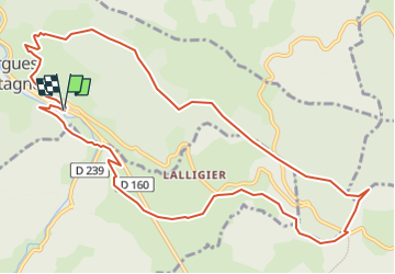

Length
13 km

Max alt
1308 m

Uphill gradient
342 m
Km-Effort
17.6 km

Min alt
1056 m

Downhill gradient
346 m
Boucle
Yes
Creation date :
2022-08-29 12:31:24.324
Updated on :
2022-09-01 16:58:10.496
3h44
Difficulty : Difficult

FREE GPS app for hiking
 SityTrail
IGN / Geographical institutes
SityTrail Plus
The world is yours!
About
Trail Walking of 13 km to be discovered at Auvergne-Rhône-Alpes, Ardèche, Saint-Cirgues-en-Montagne. This trail is proposed by raab.
Positioning
Country:
France
Region :
Auvergne-Rhône-Alpes
Department/Province :
Ardèche
Municipality :
Saint-Cirgues-en-Montagne
Location:
Unknown
Start:(Dec)
Start:(UTM)
587415 ; 4955919 (31T) N.
Comments