


30

Divio
User

Length
17.3 km

Max alt
268 m

Uphill gradient
356 m
Km-Effort
22 km

Min alt
155 m

Downhill gradient
354 m
Boucle
Yes
Creation date :
2022-08-30 06:36:26.804
Updated on :
2022-08-30 09:50:02.321
3h13
Difficulty : Very easy

FREE GPS app for hiking
 SityTrail
IGN / Geographical institutes
SityTrail Plus
The world is yours!
About
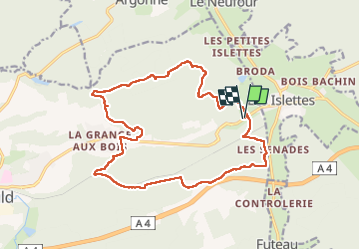
Trail Nordic walking of 17.3 km to be discovered at Grand Est, Marne, Sainte-Menehould. This trail is proposed by Divio.
Positioning
Country:
France
Region :
Grand Est
Department/Province :
Marne
Municipality :
Sainte-Menehould
Location:
Unknown
Start:(Dec)
Start:(UTM)
645232 ; 5441167 (31U) N.
Comments