


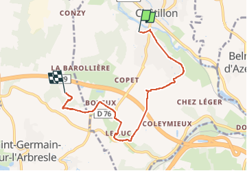
chatillon

Jean-Marc C
User

Length
6.5 km

Max alt
319 m

Uphill gradient
166 m
Km-Effort
8.5 km

Min alt
208 m

Downhill gradient
74 m
Boucle
No
Creation date :
2022-09-01 06:56:17.418
Updated on :
2022-09-01 10:19:00.744
1h50
Difficulty : Medium

FREE GPS app for hiking
 SityTrail
IGN / Geographical institutes
SityTrail Plus
The world is yours!
About
Trail Walking of 6.5 km to be discovered at Auvergne-Rhône-Alpes, Rhône, Châtillon. This trail is proposed by Jean-Marc C.
Positioning
Country:
France
Region :
Auvergne-Rhône-Alpes
Department/Province :
Rhône
Municipality :
Châtillon
Location:
Unknown
Start:(Dec)
Start:(UTM)
627321 ; 5081302 (31T) N.
Comments