


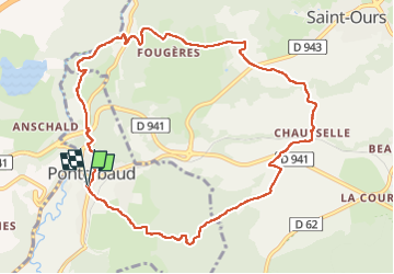
Sioule et Cheire de Pontgibaud

Gegetop
User

Length
10.9 km

Max alt
794 m

Uphill gradient
239 m
Km-Effort
14.1 km

Min alt
618 m

Downhill gradient
239 m
Boucle
Yes
Creation date :
2022-09-01 09:03:58.115
Updated on :
2022-09-01 12:53:50.39
3h11
Difficulty : Medium
2h59
Difficulty : Easy

FREE GPS app for hiking
 SityTrail
IGN / Geographical institutes
SityTrail Plus
The world is yours!
About
Trail Walking of 10.9 km to be discovered at Auvergne-Rhône-Alpes, Puy-de-Dôme, Pontgibaud. This trail is proposed by Gegetop.
Description
Boucle très agréable à faire en famille.
Photos


Positioning
Country:
France
Region :
Auvergne-Rhône-Alpes
Department/Province :
Puy-de-Dôme
Municipality :
Pontgibaud
Location:
Unknown
Start:(Dec)
Start:(UTM)
488450 ; 5075310 (31T) N.
Comments