


Chatelus à Bourganeuf

Nono55
User
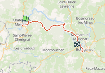

Length
19.6 km

Max alt
618 m

Uphill gradient
547 m
Km-Effort
27 km

Min alt
328 m

Downhill gradient
467 m
Boucle
No
Creation date :
2022-09-01 06:31:15.0
Updated on :
2022-09-01 14:52:30.991
5h25
Difficulty : Difficult

FREE GPS app for hiking
 SityTrail
IGN / Geographical institutes
SityTrail Plus
The world is yours!
About
Trail Walking of 19.6 km to be discovered at New Aquitaine, Creuse, Châtelus-le-Marcheix. This trail is proposed by Nono55.
Description
Départ montée difficile à froid mais beau chemin puis après beaucoup de descente
Attention descente de cailloux avant Bourganeuf
Positioning
Country:
France
Region :
New Aquitaine
Department/Province :
Creuse
Municipality :
Châtelus-le-Marcheix
Location:
Unknown
Start:(Dec)
Start:(UTM)
392117 ; 5094357 (31T) N.
Comments