Trail Walking Collioure - tour de madeloc en boucle depuis notre Dame de consolation  - Photo

tour de madeloc en boucle depuis notre Dame de consolation

© OpenStreetMap contributors
Length
Length
9.9 km
Max alt
Max alt
638 m
Uphill gradient
Uphill gradient
578 m
Km-Effort
Km-Effort  
17.6 km
Min alt
Min alt
107 m
Downhill gradient
Downhill gradient
575 m
Boucle
Boucle
Yes
Creation date :
2022-09-01 05:06:57.916
Updated on :
2022-09-01 16:32:26.486

(0 Reviews)

Walking
Walking
3h24
Difficulty : Difficult

Scan this QR Code to open this trail in the SityTrail application

FREE GPS app for hiking

Logo SityTrail SityTrail

IGN / Geographical institutes

Download SityTrail from the App Store Download SityTrail from Google Play

Logo SityTrail SityTrail Plus

The world is yours!

Download SityTrail from the App Store Download SityTrail from Google Play Download SityTrail on Huawei AppGallery

About

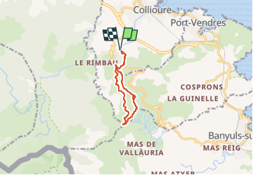
Trail Walking of 9.9 km to be discovered at Occitania, Pyrénées-Orientales, Collioure. This trail is proposed by tgvpatrickfavre.

Description

départ Notre Dame  de consolation col de la serra chemin des eaux
attention pour rejoindre la tour depuis le  col le tracé pris est difficile, pentu et parfois aérien mais
intéressant car évite de la route
retour pour Chemin muletier et parfois raide en arrivant au col de la serra et mais tracé qu à  la montée pour rejoindre le départ

Elevation profile

Positioning

Country:
France
Region :
Occitania
Department/Province :
Pyrénées-Orientales
Municipality :
Collioure
Location:
Unknown
Start:(UTM)
505543 ; 4706437 (31T) N.


Close
My subscriptions