


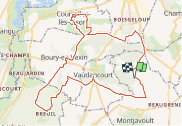
Herouval, Boury en Vexin, Vaudancourt (Gisors sud)

philberard95
User

Length
23 km

Max alt
149 m

Uphill gradient
351 m
Km-Effort
28 km

Min alt
58 m

Downhill gradient
351 m
Boucle
Yes
Creation date :
2022-09-01 16:59:09.903
Updated on :
2023-01-11 10:24:15.158
6h22
Difficulty : Very difficult

FREE GPS app for hiking
 SityTrail
IGN / Geographical institutes
SityTrail Plus
The world is yours!
About
Trail Walking of 23 km to be discovered at Hauts-de-France, Oise, Montjavoult. This trail is proposed by philberard95.
Positioning
Country:
France
Region :
Hauts-de-France
Department/Province :
Oise
Municipality :
Montjavoult
Location:
Unknown
Start:(Dec)
Start:(UTM)
411462 ; 5454041 (31U) N.
Comments