


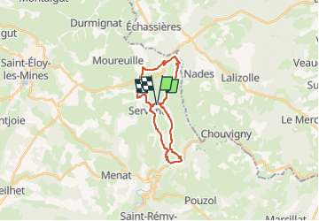
Servant la cascade de Champeaux et montignat

jeanic63
User

Length
21 km

Max alt
736 m

Uphill gradient
541 m
Km-Effort
28 km

Min alt
340 m

Downhill gradient
540 m
Boucle
Yes
Creation date :
2022-09-01 18:23:30.722
Updated on :
2022-09-05 16:58:02.211
6h14
Difficulty : Medium

FREE GPS app for hiking
 SityTrail
IGN / Geographical institutes
SityTrail Plus
The world is yours!
About
Trail On foot of 21 km to be discovered at Auvergne-Rhône-Alpes, Puy-de-Dôme, Servant. This trail is proposed by jeanic63.
Description
départ plan d'eau de servant
Positioning
Country:
France
Region :
Auvergne-Rhône-Alpes
Department/Province :
Puy-de-Dôme
Municipality :
Servant
Location:
Unknown
Start:(Dec)
Start:(UTM)
495151 ; 5109804 (31T) N.
Comments