


colorado provencal itineraire orange

guariso
User
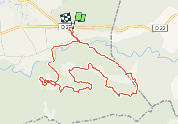

Length
6.6 km

Max alt
431 m

Uphill gradient
128 m
Km-Effort
8.3 km

Min alt
353 m

Downhill gradient
129 m
Boucle
Yes
Creation date :
2014-12-10 00:00:00.0
Updated on :
2014-12-10 00:00:00.0
2h24
Difficulty : Easy

FREE GPS app for hiking
 SityTrail
IGN / Geographical institutes
SityTrail Plus
The world is yours!
About
Trail Walking of 6.6 km to be discovered at Provence-Alpes-Côte d'Azur, Vaucluse, Rustrel. This trail is proposed by guariso.
Description
Balade a travers les ocres. Patking payant sinon stationner. A l'exterieur
Positioning
Country:
France
Region :
Provence-Alpes-Côte d'Azur
Department/Province :
Vaucluse
Municipality :
Rustrel
Location:
Unknown
Start:(Dec)
Start:(UTM)
700742 ; 4866018 (31T) N.
Comments