


St Martin Chateau à Eymoutiers

Nono55
User
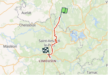

Length
26 km

Max alt
624 m

Uphill gradient
591 m
Km-Effort
35 km

Min alt
403 m

Downhill gradient
649 m
Boucle
No
Creation date :
2022-09-03 05:59:13.0
Updated on :
2022-09-04 06:20:23.909
6h39
Difficulty : Medium

FREE GPS app for hiking
 SityTrail
IGN / Geographical institutes
SityTrail Plus
The world is yours!
About
Trail Walking of 26 km to be discovered at New Aquitaine, Creuse, Saint-Martin-Château. This trail is proposed by Nono55.
Description
Parcours moyen
Mauvais balisage
Bon chemin sur la fin env 2 km
Photos


Positioning
Country:
France
Region :
New Aquitaine
Department/Province :
Creuse
Municipality :
Saint-Martin-Château
Location:
Unknown
Start:(Dec)
Start:(UTM)
406858 ; 5078947 (31T) N.
Comments