


rimouren dentde rez

brandy
User
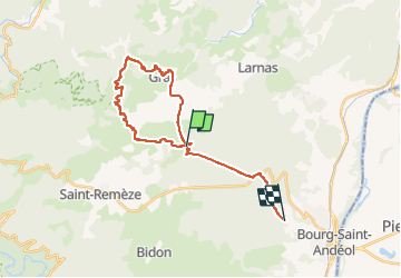

Length
26 km

Max alt
493 m

Uphill gradient
518 m
Km-Effort
33 km

Min alt
212 m

Downhill gradient
598 m
Boucle
No
Creation date :
2022-09-04 10:12:54.699
Updated on :
2022-09-04 17:59:31.101
1h36
Difficulty : Medium

FREE GPS app for hiking
 SityTrail
IGN / Geographical institutes
SityTrail Plus
The world is yours!
About
Trail Mountain bike of 26 km to be discovered at Auvergne-Rhône-Alpes, Ardèche, Gras. This trail is proposed by brandy.
Positioning
Country:
France
Region :
Auvergne-Rhône-Alpes
Department/Province :
Ardèche
Municipality :
Gras
Location:
Unknown
Start:(Dec)
Start:(UTM)
623791 ; 4918912 (31T) N.
Comments