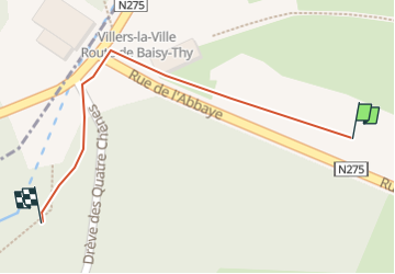
Trail Walking Villers-la-Ville - Villers la ville - Photo
© OpenStreetMap contributors
Length
Length
156 m
Max alt
Max alt
112 m
Uphill gradient
Uphill gradient
7 m
Km-Effort
Km-Effort  
226 m
Min alt
Min alt
99 m
Downhill gradient
Downhill gradient
0 m
Boucle
Boucle
No
Creation date :
2022-09-04 09:52:13.394
Updated on :
2023-05-28 08:44:48.606

(0 Reviews)

Walking
Walking
3m
Difficulty : Easy

Scan this QR Code to open this trail in the SityTrail application

FREE GPS app for hiking

Logo SityTrail SityTrail

IGN / Geographical institutes

Download SityTrail from the App Store Download SityTrail from Google Play

Logo SityTrail SityTrail Plus

The world is yours!

Download SityTrail from the App Store Download SityTrail from Google Play Download SityTrail on Huawei AppGallery

About

Trail Walking of 156 m to be discovered at Wallonia, Walloon Brabant, Villers-la-Ville. This trail is proposed by micheldutilleul.

Description

Balade dans les bois, chemins boisés et un peu de campagne. Très chouette balade, nous passons devant les ruines de l abbaye de Villers la ville.  
Attention, un petit bout du parcours est sur un sentier au mileu des marécages et zone de castors ( très humides et boueux ).

Elevation profile

Positioning

Country:
Belgium
Region :
Wallonia
Department/Province :
Walloon Brabant
Municipality :
Villers-la-Ville
Location:
Villers-la-Ville
Start:(UTM)
608179 ; 5605405 (31U) N.


Close
My subscriptions