


81-Montredon Labessonnie-sentier de Houlette

Jovila
User
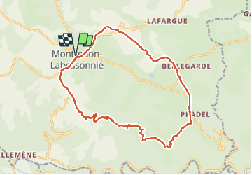

Length
20 km

Max alt
643 m

Uphill gradient
483 m
Km-Effort
27 km

Min alt
319 m

Downhill gradient
483 m
Boucle
Yes
Creation date :
2022-09-04 07:24:21.567
Updated on :
2022-09-04 20:11:27.707
4h21
Difficulty : Medium

FREE GPS app for hiking
 SityTrail
IGN / Geographical institutes
SityTrail Plus
The world is yours!
About
Trail Walking of 20 km to be discovered at Occitania, Tarn, Montredon-Labessonnié. This trail is proposed by Jovila.
Description
Beaucoup de routes à éviter pendant les grosses chaleurs !!!
Se garer au parking de l eglise -
Débuter la rando en prenant direction Arifat puis 2e à gauche.
Positioning
Country:
France
Region :
Occitania
Department/Province :
Tarn
Municipality :
Montredon-Labessonnié
Location:
Unknown
Start:(Dec)
Start:(UTM)
445685 ; 4841074 (31T) N.
Comments