


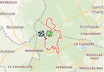
Puy des vaches

gilles cochin
User

Length
13.1 km

Max alt
1174 m

Uphill gradient
456 m
Km-Effort
19.2 km

Min alt
952 m

Downhill gradient
455 m
Boucle
Yes
Creation date :
2022-09-04 10:12:33.265
Updated on :
2022-09-04 15:04:39.745
4h11
Difficulty : Medium

FREE GPS app for hiking
 SityTrail
IGN / Geographical institutes
SityTrail Plus
The world is yours!
About
Trail Walking of 13.1 km to be discovered at Auvergne-Rhône-Alpes, Puy-de-Dôme, Aydat. This trail is proposed by gilles cochin.
Photos

Positioning
Country:
France
Region :
Auvergne-Rhône-Alpes
Department/Province :
Puy-de-Dôme
Municipality :
Aydat
Location:
Unknown
Start:(Dec)
Start:(UTM)
496225 ; 5060019 (31T) N.
Comments