


2022 09 SENART T1

michel1025
User
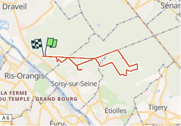

Length
13.3 km

Max alt
97 m

Uphill gradient
99 m
Km-Effort
14.6 km

Min alt
70 m

Downhill gradient
106 m
Boucle
Yes
Creation date :
2022-09-04 13:10:08.0
Updated on :
2022-09-04 16:07:13.805
2h56
Difficulty : Difficult

FREE GPS app for hiking
 SityTrail
IGN / Geographical institutes
SityTrail Plus
The world is yours!
About
Trail Walking of 13.3 km to be discovered at Ile-de-France, Essonne, Draveil. This trail is proposed by michel1025.
Positioning
Country:
France
Region :
Ile-de-France
Department/Province :
Essonne
Municipality :
Draveil
Location:
Unknown
Start:(Dec)
Start:(UTM)
457976 ; 5390225 (31U) N.
Comments