


Lac de Lignin 3

Kaiser113
User

Length
39 km

Max alt
2469 m

Uphill gradient
1551 m
Km-Effort
59 km

Min alt
1169 m

Downhill gradient
1561 m
Boucle
Yes
Creation date :
2022-09-06 17:35:36.396
Updated on :
2022-09-06 17:36:12.701
4h07
Difficulty : Very difficult

FREE GPS app for hiking
 SityTrail
IGN / Geographical institutes
SityTrail Plus
The world is yours!
About
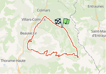
Trail Mountain bike of 39 km to be discovered at Provence-Alpes-Côte d'Azur, Alpes-de-Haute-Provence, Colmars. This trail is proposed by Kaiser113.
Positioning
Country:
France
Region :
Provence-Alpes-Côte d'Azur
Department/Province :
Alpes-de-Haute-Provence
Municipality :
Colmars
Location:
Unknown
Start:(Dec)
Start:(UTM)
313722 ; 4891322 (32T) N.
Comments