


Le collet

raygautier
User
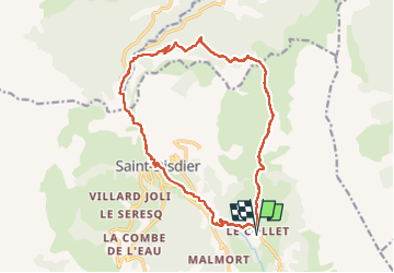

Length
17.9 km

Max alt
1686 m

Uphill gradient
942 m
Km-Effort
30 km

Min alt
879 m

Downhill gradient
943 m
Boucle
Yes
Creation date :
2022-09-06 06:27:43.0
Updated on :
2022-09-07 12:51:58.956
5h01
Difficulty : Very difficult

FREE GPS app for hiking
 SityTrail
IGN / Geographical institutes
SityTrail Plus
The world is yours!
About
Trail Walking of 17.9 km to be discovered at Provence-Alpes-Côte d'Azur, Hautes-Alpes, Le Dévoluy. This trail is proposed by raygautier.
Positioning
Country:
France
Region :
Provence-Alpes-Côte d'Azur
Department/Province :
Hautes-Alpes
Municipality :
Le Dévoluy
Location:
Saint-Étienne-en-Dévoluy
Start:(Dec)
Start:(UTM)
731797 ; 4955973 (31T) N.
Comments