


Pont de Veyle

janussity
User
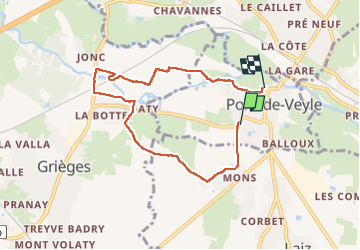

Length
6.6 km

Max alt
188 m

Uphill gradient
39 m
Km-Effort
7.1 km

Min alt
169 m

Downhill gradient
34 m
Boucle
No
Creation date :
2022-09-07 12:15:56.303
Updated on :
2022-09-07 14:06:16.459
1h41
Difficulty : Medium

FREE GPS app for hiking
 SityTrail
IGN / Geographical institutes
SityTrail Plus
The world is yours!
About
Trail Walking of 6.6 km to be discovered at Auvergne-Rhône-Alpes, Ain, Pont-de-Veyle. This trail is proposed by janussity.
Description
aquipe de Pont de Veyle 10 p
Positioning
Country:
France
Region :
Auvergne-Rhône-Alpes
Department/Province :
Ain
Municipality :
Pont-de-Veyle
Location:
Unknown
Start:(Dec)
Start:(UTM)
645075 ; 5124774 (31T) N.
Comments