


Hautes Huttes - lac Noir - Noirrrupt

lemuid
User
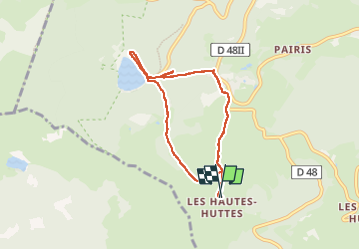

Length
6.4 km

Max alt
993 m

Uphill gradient
268 m
Km-Effort
9.9 km

Min alt
767 m

Downhill gradient
270 m
Boucle
Yes
Creation date :
2022-09-08 07:39:28.319
Updated on :
2022-09-08 14:39:21.394
2h07
Difficulty : Easy

FREE GPS app for hiking
 SityTrail
IGN / Geographical institutes
SityTrail Plus
The world is yours!
About
Trail Walking of 6.4 km to be discovered at Grand Est, Haut-Rhin, Orbey. This trail is proposed by lemuid.
Positioning
Country:
France
Region :
Grand Est
Department/Province :
Haut-Rhin
Municipality :
Orbey
Location:
Unknown
Start:(Dec)
Start:(UTM)
359453 ; 5329025 (32U) N.
Comments