


Mont Mezenc

PhilippeC54
User
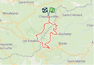

Length
26 km

Max alt
1571 m

Uphill gradient
618 m
Km-Effort
34 km

Min alt
1224 m

Downhill gradient
624 m
Boucle
Yes
Creation date :
2022-09-08 07:14:35.992
Updated on :
2022-09-09 07:28:25.161
1h59
Difficulty : Medium

FREE GPS app for hiking
 SityTrail
IGN / Geographical institutes
SityTrail Plus
The world is yours!
About
Trail Road bike of 26 km to be discovered at Auvergne-Rhône-Alpes, Haute-Loire, Chaudeyrolles. This trail is proposed by PhilippeC54.
Positioning
Country:
France
Region :
Auvergne-Rhône-Alpes
Department/Province :
Haute-Loire
Municipality :
Chaudeyrolles
Location:
Unknown
Start:(Dec)
Start:(UTM)
594844 ; 4978069 (31T) N.
Comments