


6.1 km | 8.9 km-effort

User GUIDE


FREE GPS app for hiking
 SityTrail
IGN / Geographical institutes
SityTrail World
The world is yours!
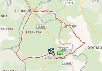
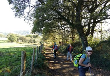
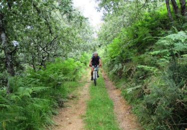
Trail Walking of 10.3 km to be discovered at New Aquitaine, Pyrénées-Atlantiques, Uhart-Mixe. This trail is proposed by marmotte65.
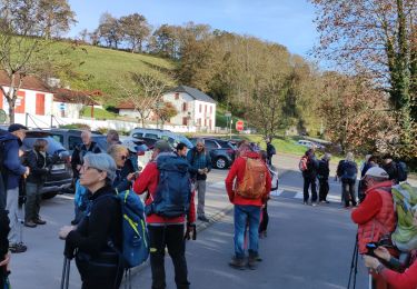
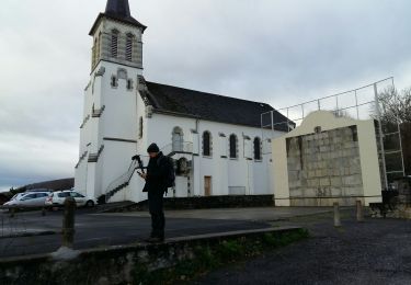
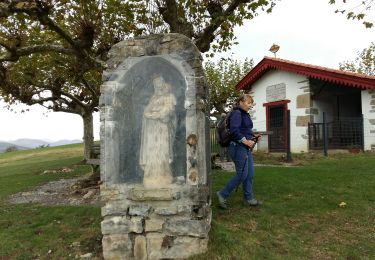
un petit groupe partir à 10 h de l'église de Uhart Mixe pour attendre le point culminant (la chapelle de Soyarza lieu de recueillement et de PN 7.7 km )
Une belle balade un peu ternie par les 4.5 km de goudron depuis le départ, mais compensée par de beau point de vue de jolis sentiers la stèle de Gibraltar, et la fameuse chapelle .
Pour un groupe plus important 25/30 personnes prévoir le depart 1/2 h plus tot avec possibilite de parking au cimetiere 100 m plus loin
 "
data-pinterest-text="Pin it"
data-tweet-text="share on twitter"
data-facebook-share-url="https://www.sitytrail.com/en/trails/3385179-uhartxmixe--uhart-mixe-reco--du-5x11x2022-circuit-urbeltz-journee-presidents--x3385179xet-animateurs/?photo=1#lg=1&slide=1"
data-twitter-share-url="https://www.sitytrail.com/en/trails/3385179-uhartxmixe--uhart-mixe-reco--du-5x11x2022-circuit-urbeltz-journee-presidents--x3385179xet-animateurs/?photo=1#lg=1&slide=1"
data-googleplus-share-url="https://www.sitytrail.com/en/trails/3385179-uhartxmixe--uhart-mixe-reco--du-5x11x2022-circuit-urbeltz-journee-presidents--x3385179xet-animateurs/?photo=1#lg=1&slide=1"
data-pinterest-share-url="https://www.sitytrail.com/en/trails/3385179-uhartxmixe--uhart-mixe-reco--du-5x11x2022-circuit-urbeltz-journee-presidents--x3385179xet-animateurs/?photo=1#lg=1&slide=1">
"
data-pinterest-text="Pin it"
data-tweet-text="share on twitter"
data-facebook-share-url="https://www.sitytrail.com/en/trails/3385179-uhartxmixe--uhart-mixe-reco--du-5x11x2022-circuit-urbeltz-journee-presidents--x3385179xet-animateurs/?photo=1#lg=1&slide=1"
data-twitter-share-url="https://www.sitytrail.com/en/trails/3385179-uhartxmixe--uhart-mixe-reco--du-5x11x2022-circuit-urbeltz-journee-presidents--x3385179xet-animateurs/?photo=1#lg=1&slide=1"
data-googleplus-share-url="https://www.sitytrail.com/en/trails/3385179-uhartxmixe--uhart-mixe-reco--du-5x11x2022-circuit-urbeltz-journee-presidents--x3385179xet-animateurs/?photo=1#lg=1&slide=1"
data-pinterest-share-url="https://www.sitytrail.com/en/trails/3385179-uhartxmixe--uhart-mixe-reco--du-5x11x2022-circuit-urbeltz-journee-presidents--x3385179xet-animateurs/?photo=1#lg=1&slide=1">
 "
data-pinterest-text="Pin it"
data-tweet-text="share on twitter"
data-facebook-share-url="https://www.sitytrail.com/en/trails/3385179-uhartxmixe--uhart-mixe-reco--du-5x11x2022-circuit-urbeltz-journee-presidents--x3385179xet-animateurs/?photo=2#lg=1&slide=2"
data-twitter-share-url="https://www.sitytrail.com/en/trails/3385179-uhartxmixe--uhart-mixe-reco--du-5x11x2022-circuit-urbeltz-journee-presidents--x3385179xet-animateurs/?photo=2#lg=1&slide=2"
data-googleplus-share-url="https://www.sitytrail.com/en/trails/3385179-uhartxmixe--uhart-mixe-reco--du-5x11x2022-circuit-urbeltz-journee-presidents--x3385179xet-animateurs/?photo=2#lg=1&slide=2"
data-pinterest-share-url="https://www.sitytrail.com/en/trails/3385179-uhartxmixe--uhart-mixe-reco--du-5x11x2022-circuit-urbeltz-journee-presidents--x3385179xet-animateurs/?photo=2#lg=1&slide=2">
"
data-pinterest-text="Pin it"
data-tweet-text="share on twitter"
data-facebook-share-url="https://www.sitytrail.com/en/trails/3385179-uhartxmixe--uhart-mixe-reco--du-5x11x2022-circuit-urbeltz-journee-presidents--x3385179xet-animateurs/?photo=2#lg=1&slide=2"
data-twitter-share-url="https://www.sitytrail.com/en/trails/3385179-uhartxmixe--uhart-mixe-reco--du-5x11x2022-circuit-urbeltz-journee-presidents--x3385179xet-animateurs/?photo=2#lg=1&slide=2"
data-googleplus-share-url="https://www.sitytrail.com/en/trails/3385179-uhartxmixe--uhart-mixe-reco--du-5x11x2022-circuit-urbeltz-journee-presidents--x3385179xet-animateurs/?photo=2#lg=1&slide=2"
data-pinterest-share-url="https://www.sitytrail.com/en/trails/3385179-uhartxmixe--uhart-mixe-reco--du-5x11x2022-circuit-urbeltz-journee-presidents--x3385179xet-animateurs/?photo=2#lg=1&slide=2">
 "
data-pinterest-text="Pin it"
data-tweet-text="share on twitter"
data-facebook-share-url="https://www.sitytrail.com/en/trails/3385179-uhartxmixe--uhart-mixe-reco--du-5x11x2022-circuit-urbeltz-journee-presidents--x3385179xet-animateurs/?photo=3#lg=1&slide=3"
data-twitter-share-url="https://www.sitytrail.com/en/trails/3385179-uhartxmixe--uhart-mixe-reco--du-5x11x2022-circuit-urbeltz-journee-presidents--x3385179xet-animateurs/?photo=3#lg=1&slide=3"
data-googleplus-share-url="https://www.sitytrail.com/en/trails/3385179-uhartxmixe--uhart-mixe-reco--du-5x11x2022-circuit-urbeltz-journee-presidents--x3385179xet-animateurs/?photo=3#lg=1&slide=3"
data-pinterest-share-url="https://www.sitytrail.com/en/trails/3385179-uhartxmixe--uhart-mixe-reco--du-5x11x2022-circuit-urbeltz-journee-presidents--x3385179xet-animateurs/?photo=3#lg=1&slide=3">
"
data-pinterest-text="Pin it"
data-tweet-text="share on twitter"
data-facebook-share-url="https://www.sitytrail.com/en/trails/3385179-uhartxmixe--uhart-mixe-reco--du-5x11x2022-circuit-urbeltz-journee-presidents--x3385179xet-animateurs/?photo=3#lg=1&slide=3"
data-twitter-share-url="https://www.sitytrail.com/en/trails/3385179-uhartxmixe--uhart-mixe-reco--du-5x11x2022-circuit-urbeltz-journee-presidents--x3385179xet-animateurs/?photo=3#lg=1&slide=3"
data-googleplus-share-url="https://www.sitytrail.com/en/trails/3385179-uhartxmixe--uhart-mixe-reco--du-5x11x2022-circuit-urbeltz-journee-presidents--x3385179xet-animateurs/?photo=3#lg=1&slide=3"
data-pinterest-share-url="https://www.sitytrail.com/en/trails/3385179-uhartxmixe--uhart-mixe-reco--du-5x11x2022-circuit-urbeltz-journee-presidents--x3385179xet-animateurs/?photo=3#lg=1&slide=3">
 "
data-pinterest-text="Pin it"
data-tweet-text="share on twitter"
data-facebook-share-url="https://www.sitytrail.com/en/trails/3385179-uhartxmixe--uhart-mixe-reco--du-5x11x2022-circuit-urbeltz-journee-presidents--x3385179xet-animateurs/?photo=4#lg=1&slide=4"
data-twitter-share-url="https://www.sitytrail.com/en/trails/3385179-uhartxmixe--uhart-mixe-reco--du-5x11x2022-circuit-urbeltz-journee-presidents--x3385179xet-animateurs/?photo=4#lg=1&slide=4"
data-googleplus-share-url="https://www.sitytrail.com/en/trails/3385179-uhartxmixe--uhart-mixe-reco--du-5x11x2022-circuit-urbeltz-journee-presidents--x3385179xet-animateurs/?photo=4#lg=1&slide=4"
data-pinterest-share-url="https://www.sitytrail.com/en/trails/3385179-uhartxmixe--uhart-mixe-reco--du-5x11x2022-circuit-urbeltz-journee-presidents--x3385179xet-animateurs/?photo=4#lg=1&slide=4">
"
data-pinterest-text="Pin it"
data-tweet-text="share on twitter"
data-facebook-share-url="https://www.sitytrail.com/en/trails/3385179-uhartxmixe--uhart-mixe-reco--du-5x11x2022-circuit-urbeltz-journee-presidents--x3385179xet-animateurs/?photo=4#lg=1&slide=4"
data-twitter-share-url="https://www.sitytrail.com/en/trails/3385179-uhartxmixe--uhart-mixe-reco--du-5x11x2022-circuit-urbeltz-journee-presidents--x3385179xet-animateurs/?photo=4#lg=1&slide=4"
data-googleplus-share-url="https://www.sitytrail.com/en/trails/3385179-uhartxmixe--uhart-mixe-reco--du-5x11x2022-circuit-urbeltz-journee-presidents--x3385179xet-animateurs/?photo=4#lg=1&slide=4"
data-pinterest-share-url="https://www.sitytrail.com/en/trails/3385179-uhartxmixe--uhart-mixe-reco--du-5x11x2022-circuit-urbeltz-journee-presidents--x3385179xet-animateurs/?photo=4#lg=1&slide=4">
 "
data-pinterest-text="Pin it"
data-tweet-text="share on twitter"
data-facebook-share-url="https://www.sitytrail.com/en/trails/3385179-uhartxmixe--uhart-mixe-reco--du-5x11x2022-circuit-urbeltz-journee-presidents--x3385179xet-animateurs/?photo=5#lg=1&slide=5"
data-twitter-share-url="https://www.sitytrail.com/en/trails/3385179-uhartxmixe--uhart-mixe-reco--du-5x11x2022-circuit-urbeltz-journee-presidents--x3385179xet-animateurs/?photo=5#lg=1&slide=5"
data-googleplus-share-url="https://www.sitytrail.com/en/trails/3385179-uhartxmixe--uhart-mixe-reco--du-5x11x2022-circuit-urbeltz-journee-presidents--x3385179xet-animateurs/?photo=5#lg=1&slide=5"
data-pinterest-share-url="https://www.sitytrail.com/en/trails/3385179-uhartxmixe--uhart-mixe-reco--du-5x11x2022-circuit-urbeltz-journee-presidents--x3385179xet-animateurs/?photo=5#lg=1&slide=5">
"
data-pinterest-text="Pin it"
data-tweet-text="share on twitter"
data-facebook-share-url="https://www.sitytrail.com/en/trails/3385179-uhartxmixe--uhart-mixe-reco--du-5x11x2022-circuit-urbeltz-journee-presidents--x3385179xet-animateurs/?photo=5#lg=1&slide=5"
data-twitter-share-url="https://www.sitytrail.com/en/trails/3385179-uhartxmixe--uhart-mixe-reco--du-5x11x2022-circuit-urbeltz-journee-presidents--x3385179xet-animateurs/?photo=5#lg=1&slide=5"
data-googleplus-share-url="https://www.sitytrail.com/en/trails/3385179-uhartxmixe--uhart-mixe-reco--du-5x11x2022-circuit-urbeltz-journee-presidents--x3385179xet-animateurs/?photo=5#lg=1&slide=5"
data-pinterest-share-url="https://www.sitytrail.com/en/trails/3385179-uhartxmixe--uhart-mixe-reco--du-5x11x2022-circuit-urbeltz-journee-presidents--x3385179xet-animateurs/?photo=5#lg=1&slide=5">
 "
data-pinterest-text="Pin it"
data-tweet-text="share on twitter"
data-facebook-share-url="https://www.sitytrail.com/en/trails/3385179-uhartxmixe--uhart-mixe-reco--du-5x11x2022-circuit-urbeltz-journee-presidents--x3385179xet-animateurs/?photo=6#lg=1&slide=6"
data-twitter-share-url="https://www.sitytrail.com/en/trails/3385179-uhartxmixe--uhart-mixe-reco--du-5x11x2022-circuit-urbeltz-journee-presidents--x3385179xet-animateurs/?photo=6#lg=1&slide=6"
data-googleplus-share-url="https://www.sitytrail.com/en/trails/3385179-uhartxmixe--uhart-mixe-reco--du-5x11x2022-circuit-urbeltz-journee-presidents--x3385179xet-animateurs/?photo=6#lg=1&slide=6"
data-pinterest-share-url="https://www.sitytrail.com/en/trails/3385179-uhartxmixe--uhart-mixe-reco--du-5x11x2022-circuit-urbeltz-journee-presidents--x3385179xet-animateurs/?photo=6#lg=1&slide=6">
"
data-pinterest-text="Pin it"
data-tweet-text="share on twitter"
data-facebook-share-url="https://www.sitytrail.com/en/trails/3385179-uhartxmixe--uhart-mixe-reco--du-5x11x2022-circuit-urbeltz-journee-presidents--x3385179xet-animateurs/?photo=6#lg=1&slide=6"
data-twitter-share-url="https://www.sitytrail.com/en/trails/3385179-uhartxmixe--uhart-mixe-reco--du-5x11x2022-circuit-urbeltz-journee-presidents--x3385179xet-animateurs/?photo=6#lg=1&slide=6"
data-googleplus-share-url="https://www.sitytrail.com/en/trails/3385179-uhartxmixe--uhart-mixe-reco--du-5x11x2022-circuit-urbeltz-journee-presidents--x3385179xet-animateurs/?photo=6#lg=1&slide=6"
data-pinterest-share-url="https://www.sitytrail.com/en/trails/3385179-uhartxmixe--uhart-mixe-reco--du-5x11x2022-circuit-urbeltz-journee-presidents--x3385179xet-animateurs/?photo=6#lg=1&slide=6">
 "
data-pinterest-text="Pin it"
data-tweet-text="share on twitter"
data-facebook-share-url="https://www.sitytrail.com/en/trails/3385179-uhartxmixe--uhart-mixe-reco--du-5x11x2022-circuit-urbeltz-journee-presidents--x3385179xet-animateurs/?photo=7#lg=1&slide=7"
data-twitter-share-url="https://www.sitytrail.com/en/trails/3385179-uhartxmixe--uhart-mixe-reco--du-5x11x2022-circuit-urbeltz-journee-presidents--x3385179xet-animateurs/?photo=7#lg=1&slide=7"
data-googleplus-share-url="https://www.sitytrail.com/en/trails/3385179-uhartxmixe--uhart-mixe-reco--du-5x11x2022-circuit-urbeltz-journee-presidents--x3385179xet-animateurs/?photo=7#lg=1&slide=7"
data-pinterest-share-url="https://www.sitytrail.com/en/trails/3385179-uhartxmixe--uhart-mixe-reco--du-5x11x2022-circuit-urbeltz-journee-presidents--x3385179xet-animateurs/?photo=7#lg=1&slide=7">
"
data-pinterest-text="Pin it"
data-tweet-text="share on twitter"
data-facebook-share-url="https://www.sitytrail.com/en/trails/3385179-uhartxmixe--uhart-mixe-reco--du-5x11x2022-circuit-urbeltz-journee-presidents--x3385179xet-animateurs/?photo=7#lg=1&slide=7"
data-twitter-share-url="https://www.sitytrail.com/en/trails/3385179-uhartxmixe--uhart-mixe-reco--du-5x11x2022-circuit-urbeltz-journee-presidents--x3385179xet-animateurs/?photo=7#lg=1&slide=7"
data-googleplus-share-url="https://www.sitytrail.com/en/trails/3385179-uhartxmixe--uhart-mixe-reco--du-5x11x2022-circuit-urbeltz-journee-presidents--x3385179xet-animateurs/?photo=7#lg=1&slide=7"
data-pinterest-share-url="https://www.sitytrail.com/en/trails/3385179-uhartxmixe--uhart-mixe-reco--du-5x11x2022-circuit-urbeltz-journee-presidents--x3385179xet-animateurs/?photo=7#lg=1&slide=7">
 "
data-pinterest-text="Pin it"
data-tweet-text="share on twitter"
data-facebook-share-url="https://www.sitytrail.com/en/trails/3385179-uhartxmixe--uhart-mixe-reco--du-5x11x2022-circuit-urbeltz-journee-presidents--x3385179xet-animateurs/?photo=8#lg=1&slide=8"
data-twitter-share-url="https://www.sitytrail.com/en/trails/3385179-uhartxmixe--uhart-mixe-reco--du-5x11x2022-circuit-urbeltz-journee-presidents--x3385179xet-animateurs/?photo=8#lg=1&slide=8"
data-googleplus-share-url="https://www.sitytrail.com/en/trails/3385179-uhartxmixe--uhart-mixe-reco--du-5x11x2022-circuit-urbeltz-journee-presidents--x3385179xet-animateurs/?photo=8#lg=1&slide=8"
data-pinterest-share-url="https://www.sitytrail.com/en/trails/3385179-uhartxmixe--uhart-mixe-reco--du-5x11x2022-circuit-urbeltz-journee-presidents--x3385179xet-animateurs/?photo=8#lg=1&slide=8">
"
data-pinterest-text="Pin it"
data-tweet-text="share on twitter"
data-facebook-share-url="https://www.sitytrail.com/en/trails/3385179-uhartxmixe--uhart-mixe-reco--du-5x11x2022-circuit-urbeltz-journee-presidents--x3385179xet-animateurs/?photo=8#lg=1&slide=8"
data-twitter-share-url="https://www.sitytrail.com/en/trails/3385179-uhartxmixe--uhart-mixe-reco--du-5x11x2022-circuit-urbeltz-journee-presidents--x3385179xet-animateurs/?photo=8#lg=1&slide=8"
data-googleplus-share-url="https://www.sitytrail.com/en/trails/3385179-uhartxmixe--uhart-mixe-reco--du-5x11x2022-circuit-urbeltz-journee-presidents--x3385179xet-animateurs/?photo=8#lg=1&slide=8"
data-pinterest-share-url="https://www.sitytrail.com/en/trails/3385179-uhartxmixe--uhart-mixe-reco--du-5x11x2022-circuit-urbeltz-journee-presidents--x3385179xet-animateurs/?photo=8#lg=1&slide=8">


Walking
Walking
Walking
Walking
Walking
Walking
Walking

Walking
Mountain bike