


La Croix de Briges

PhilippeC54
User
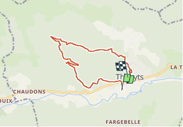

Length
7.3 km

Max alt
746 m

Uphill gradient
290 m
Km-Effort
11.2 km

Min alt
463 m

Downhill gradient
284 m
Boucle
No
Creation date :
2022-09-09 12:53:21.508
Updated on :
2022-09-09 15:08:11.781
2h03
Difficulty : Easy

FREE GPS app for hiking
 SityTrail
IGN / Geographical institutes
SityTrail Plus
The world is yours!
About
Trail Walking of 7.3 km to be discovered at Auvergne-Rhône-Alpes, Ardèche, Thueyts. This trail is proposed by PhilippeC54.
Positioning
Country:
France
Region :
Auvergne-Rhône-Alpes
Department/Province :
Ardèche
Municipality :
Thueyts
Location:
Unknown
Start:(Dec)
Start:(UTM)
596620 ; 4947280 (31T) N.
Comments